
Navigation
User login
ViBRANT is funded by the European Union 7th Framework Programme within the Research Infrastructures group.
Contract no. RI-261532. Period, Dec. 2010 to Nov. 2013. Coordinator: Dr Vince Smith. E-mail: enquiries@vbrant.eu
Visualisation
Javier de la Torre (Vizzuality)
Summary
GeoCAT is an open source, browser based tool that performs rapid geospatial analysis to ease the process of Red Listing taxa. Developed to utilise spatially referenced primary occurrence data, the analysis focuses on two aspects of the geographic range of a taxon: the extent of occurrence (EOO) and the area of occupancy (AOO). These metrics form part of the IUCN Red List categories and criteria and have often proved challenging to obtain in an accurate, consistent and repeatable way. Within a familiar Google Maps environment, GeoCAT users can quickly and easily combine data from multiple sources such as GBIF, Flickr and Scratchpads as well as user generated occurrence data. Analysis is done with the click of a button and is visualised instantly, providing an indication of the Red List threat rating, subject to meeting the full requirements of the criteria. Outputs including the results, data and parameters used for analysis are stored in a GeoCAT file that can be easily reloaded or shared with collaborators. GeoCAT is a first step toward automating the data handling process of Red List assessing and provides a valuable hub from which further developments and enhancements can be spawned. GeoCAT will be open to a broader community from January 2012.
Description
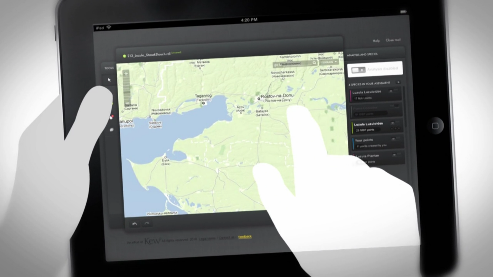
The tool allows conservation assessments to be produced in Google Maps from specimen locality pointdata or primary occurrence data (see image below). The tool automatically calculates measures associated with the IUCN Red List categories and criteria (IUCN 2001) - the most respected and globally used system for assessing extinction risk.
|
 |
||||||||||||||||||
Specifically the tool calculates Extent of Occurrence (EOO), Area of Occupancy (AOO), number of localities and number of subpopulations for any species, from a database of georeferenced specimens, and assesses these measures against the thresholds of the IUCN Red List Categories (IUCN 2001).
Traditionally these analyses have been done using proprietary GIS software such as ArcGIS. The tool developed at ViBRANT will be free and Open Source. By making them available as an online tool anyone interested in conservation and with access to the internet will have ease of access to a quick, quantifiable and repeatable species conservation assessment tool without the overheads of a full GIS with its associated learning curve and costs.
GeoCAT Ecological Boundaries
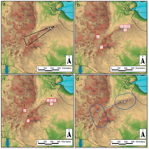
Preliminary GIS analysis of Aloe pubescens Reynolds from the highlands of Ethiopia using georeferenced specimens from the herbarium at the Royal Botanic Gardens, Kew, showing (a) the extent of occurrence, measured as a convex hull; (b) the area of occupancy, measured with a cell width of 48 km; (c) the number of subpopulations using the cell-adjacency method of Schatz et al. (2000); and (d) the number of subpopulations using Rapoportʼs principle of mean propinquity (Rapoport 1982; see also Willis et al. 2003)
Further Development
- Read Primary data from Scratchpads
- Visualise other layers like Protected Areas, Range maps...
- Overlay Niche models
- Visualization of the temporal component
- Be able to visualise results through the ViBRANT OBOE service
Citations
[1] Friis I, Wilmot-Dear M, Edmondson JR, Wondafrash M, Demissew S (2012) The genus Plumbago (Plumbaginaceae) in Ethiopia and Eritrea. Webbia 67(2), 157-177.
[2] Wilkin P, Suksathan P, Keeratikiat K, Van Welzen P, Wiland-Szymańska J (2012). A new threatened endemic species from central and northeastern Thailand, Dracaena jayniana (Asparagaceae: tribe Nolinoideae). Kew Bulletin 1-9
[3] Rakotonirina N, Rakouth B, Davis AP (2012) A taxonomic revision of Madagascan Gardenia (Rubiaceae, Gardenieae). Nordic Journal of Botany 30(6):712-728.
[4] Lambdon P, Darlow A, Lubbe C, Cope T (2012) Eragrostis episcopulus-a newly described grass species endemic to the island of St. Helena, its ecology and conservation. Kew Bulletin 1–11
[5] Zubov DA, Davis AP (2012) Galanthus panjutinii sp. nov.: a new name for an invalidly published species of Galanthus (Amaryllidaceae) from the northern Colchis area of Western Transcaucasia. Phylotaxa 50, 55-63.
[6] De Stefano RD, Janovec JP, Can LL (2013) Three decades to connect the sexes: Calatola microcarpa (Icacinaceae), a new species from the Southwestern Amazon. Phytotaxa 124(1), 43-49.
[7] Upson R, Clubbe C, Hind DJN (2013). Nassauvia falklandica (Compositae: Mutisieae: Nassauviinae), a new endemic species for the Falkland Islands Kew Bulletin
[8] Niemiller ML, Graening GO, Fenolio DB, Godwin JC, Cooley JR, Pearson WD, Fitzpatrick BM, Near TJ (2013). Doomed before they are described? The need for conservation assessments of cryptic species complexes using an amblyopsid cavefish (Amblyopsidae: Typhlichthys) as a case study Biodiversity and Conservation
[9] Candela L, Castelli D, Coro G, Pagano P, Sinibaldi F (2013). Species distribution modeling in the cloud Concurrency and Computation: Practice and Experience
[10] De Stefano RD, MDLR Arce, JEL Conteras, Can LL, Ruis SC (2013) Re-establishment of Pithecellobium subglobosum in Colombia and Venezuela (Leguminosae, Mimosoideae, tribe Ingeae). Phytotaxa 138(1), 15-24.
[11] Besnard G, Christin PA, Malé PJG, Coissac E, Ralimanana H, Vorontsova MS (2013) Phylogenomics and taxonomy of Lecomtelleae (Poaceae), an isolated panicoid lineage from Madagascar. Annals of botany 112(6), 1057-1066.
References
[1] Rapoport E (1982) Areography: geographical strategies of species. Pergamon Press, New York
[2] Schatz G, Birkinshaw C, Lowry PP II, Randriantafika F, Ratovoson F (2000) The endemic plant families of Madagascar project: integrating taxonomy and conservation. In: Lourenço WR, Goodman SM (eds) Diversité et Endemisme à Madagascar. Mem Soc Biogeogr, Paris, p 11 – 24
[3] Willis F, Moat J, Paton A (2003) Defining a role for herbarium data in Red List assessments: a case study of Plectranthus from eastern and southern tropical Africa. Biodivers Conserv 12:1537–1552